
300-meter stretch of ancient aqueduct uncovered during planning for new Jerusalem neighborhood
Newly discovered section of the city’s ancient water system will be prominently displayed in development south of Ramat Rachel, highlighting its significant history
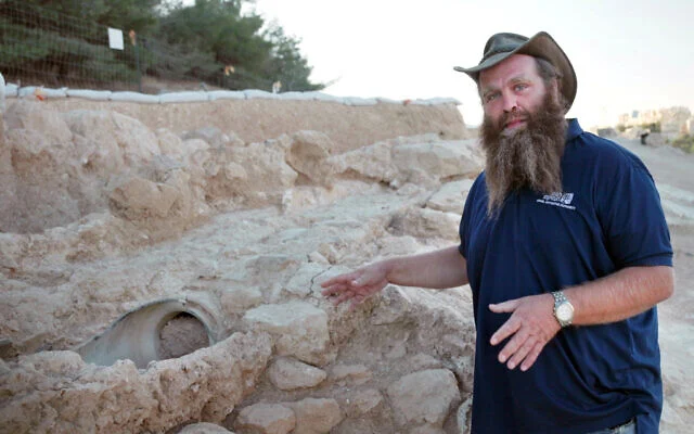
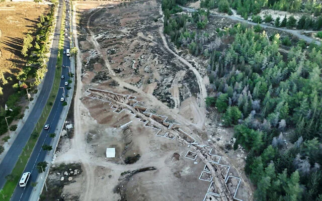
Archaeologists have uncovered a 300-meter (1,000-foot) stretch of a 2,000-year-old aqueduct that carried water from springs south of Bethlehem to Jerusalem’s Temple Mount, shedding new light on one of the ancient city’s most ambitious engineering projects.
The discovery was made ahead of plans to build a new neighborhood in southern Jerusalem, where archaeologists and planners hope to incorporate the remains into the future development, according to an announcement Sunday by the Israel Antiquities Authority.
The discovery provides new information about the “engineering marvel” that once served as the city’s main water source, Benyamin Storchan, one of the site’s excavation directors, told The Times of Israel. The findings highlight a fascinating — but not very widely known — aspect of Jerusalem’s history, he added.
An ancient engineering feat
Access to water has always been a challenge for Jerusalem, situated high in the central plateau of the Judaean Mountains, Storchan explained. Annual rainfall and the water from the Gihon Spring, at the bottom of the Kidron Valley, were not enough to meet the needs of the city during the Second Temple period, especially when its population swelled during the pilgrimage festivals.
Constructing an aqueduct to bring water from springs in the Judaean lowlands would have required a technological innovation to bring the water uphill, due to the incline in elevation. So around 100 BCE, Hasmonean kings built a waterway, now known as the Lower Aqueduct, that would transport water 21 kilometers (13 miles) from the three springs known as Solomon’s Pools, south of Bethlehem, to the Temple Mount in Jerusalem.
“The construction is not like what you would imagine when you picture the aqueducts in Caesarea or Italy with large bridges and arches,” Storchan said. “It’s much simpler — a wall built of two rows of stones, with a U-shaped channel inside that was plastered and probably covered on top by stone slabs.”
The difference in elevation between the starting and ending points of the waterway is only about 30 meters (98 feet), giving the ancient engineers little room for error, Storchan said. That meant water had to flow along a very gentle gradient, dropping just one meter in elevation per kilometer (five feet per mile).
The water was guided by gravity, without assistance from pumps or other mechanical devices. In some places, engineers had to cut through mountains and create tunnels because looping around them would lose too much of the gradient, Storchan noted. Cleanout points were installed along the system, providing access to the channel to clear blockages and perform maintenance.
“The aqueduct is an engineering marvel,” said IAA Jerusalem District Archaeologist Amit Re’em in a statement. “The thought that about 2,000 years ago they managed to bring water to Jerusalem this way is astonishing.”
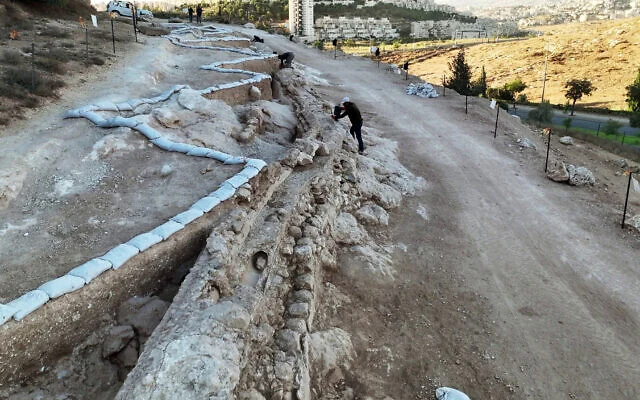
The system was so well planned that it remained in intermittent use until about 100 years ago, Storchan said. During the Ottoman period, about 500 years ago, ceramic pipes were installed within the original channel to upgrade the system for continued use.
A later waterway known as the Upper Aqueduct, channeling water to elites in Jerusalem’s upper city, was more technologically advanced, but the engineering simplicity of the Lower Aqueduct allowed it to remain in use for about 1,000 years longer, Storchan noted.
“The initial surveyors did a wonderful job, even though it seems like they did this the harder way,” Storchan said. “They relied on simple mathematical calculations, and showed that our most time-proven tools — the human brain and the desire to build — can be more powerful than sophisticated technologies.”
Modern research and development
Over the centuries, portions of the aqueduct system were maintained, modified, and destroyed. Storchan and his co-directors of the excavation, Gil Freid and Rotem Cohen, are trying to understand how its use evolved over time.
Different portions of the aqueducts have been uncovered over the years, including recent finds in Jerusalem’s Armon Hanetziv neighborhood, Givat Hamatos, Ramat Rachel and East Jerusalem.
The most recent discovery took place as Jerusalem looks to develop a new residential neighborhood on the southern flank of Ramat Rachel, Storchan said. This project, currently known as the Lower Aqueduct plan and many years from completion, is expected to eventually include up to 1,800 residential units and connect Ramat Rachel with the adjoining neighborhoods of Giv’at HaMatos and Har Homa. (It will also block a potential contiguous expansion between East Jerusalem and Bethlehem, to the dismay of international organizations.)
The Israel Land Authority and the Israel Antiquities Authority will work together with archaeologists to integrate the aqueduct’s history into the community’s identity.
In other neighborhoods, sections of the aqueduct appear as isolated remnants, surrounded or overshadowed by later buildings, without offering a sense of their historic significance, Storchan said. However, for the new development, government bodies planned the project around the archaeology from the beginning.
“One of the dreams is to create a promenade along the aqueduct, keeping the integrity of the ancient remains and placing them front and center,” Storchan said. “The archaeology will visible as you enter the neighborhood, and people there will know about it.”
The IAA also plans to create a continuous park that will allow people to walk alongside the aqueduct from southern Jerusalem to the Old City, Re’em noted.
Meanwhile, researchers are also working on a new effort to map the aqueduct’s exact course. While scientists have had a rough map of the route for years, only about two kilometers of the 21-kilometer route has actually been excavated.
Freid has used high-precision satellite technology to establish what he believes is the exact path of the waterway, at least in the area north of the modern Jerusalem neighborhood of Gilo. (Excavations in the West Bank are controlled by a different organization.)
This research, which will be presented publicly at the “New Studies in the Archaeology of Jerusalem and its Region” conference this week, can help researchers reconstruct the route where modern construction has erased the physical remains, Storchan said.
Meanwhile, more work remains to be done to uncover the ancient aqueduct’s secrets, Storchan said.
“What we’re doing is filling in small pieces of the puzzle,” he said. “Different segments have been uncovered over the last century, and today, we are capable of asking questions and researching aspects that you couldn’t have dreamed of a few decades ago.”
“The more we uncover now,” he said, “the better questions we can ask in the future.” PJC
comments